Day 15 - Eighty Mile Beach to Tom Price
Time to make up for a couple short days, although not without the motivation of a 'gorgeous' swimming hole or three.
Quick Stats
- 7 hours on bike
- 699 km
- 6384 km total
My main aim for the day is to get to Karijini National Park early enough to do some exploring, but I've got six hours ride to do before that.
With such a big day ahead, I prepacked the bike last night to leave at 6.30 am sharp. So I leave Eighty Mile Beach at 7.48 am.
The section after pulling onto the Great Northern Hwy continues to be as boring as the last two hours yesterday. It really is hard to explain just how much open nothingness there is out here.
Two hours later, the three memorable landmarks that broke up the ride were a couple of dead cows, and an ancient worn out sign welcoming me to the Pilbara.
The Pilbara is a massive expanse across the third quarter of Western Australia. Its famous for its red dirt and its mineral deposits. Iron ore. Its famous for all the iron ore we dig out of it. Not a whole lot else.
Just passed the welcome sign is the Pardoo Roadhouse. Its closed following Cyclone Ilsa in April this year, so I guess its another hours wait for my morning coffee. On to Port Hedland.
Eager to keep going, I detour towards South Hedland, grab some fuel and duck in for a quick coffee and some supplies.

I leave Hedland heading straight south, continuing to follow the Great Northern Hwy, rather the heading east along the coast to Karratha and Onslow.
Since getting to Hedland the ratio of caravans to mining trucks has plummeted. It seems no one is out here that wants to be. It's more monotony for the first two hundred kilometres and I'm second guessing if this detour is worth it.
But I'm told there's something else the Pilbara has going for it. And it lives inside the Hamersley ranges. I pull in for another fuel up in Munjina and I can see the range in the distance.

The Hamersley is known for its banded iron ore, they remove over a hundred million tonnes of the stuff every year. Its also home to all top twenty of the highest mountains in WA (Mt Meharry is the tallest at 1249 metres).
It was hot again this morning, peaking at 31°C, but ever since leaving Hedland I've been gaining elevation and the temperature has slowly dropped. 30°C... 29... I cross the Fortescue River (well, dry river bed) and pass above 500 metres elevation. Down to 28 now.
In amongst all those mountains nestles Karijini National Park. And it's not far now. I head another 20 minutes down the highway and turn onto Karijini Road. Half an hour later and I pull up to the first lookout.

It doesn't look all that promising, just more red dirt and iron ore...

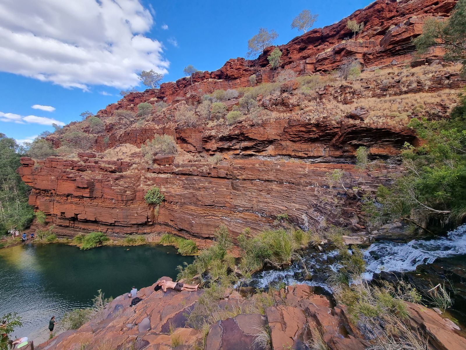
Oh.. now that's interesting. And there's a swimming hole down there.

I strap on my shoes and head on down.


And I'm in. Fortescue Falls is the only permanent waterfall in the park. The water is spectacularly cool. I can't stay too long though, more to explore and its already 3 pm.
Onto the next swimming hole. And then a quick three kilometre jog up the gorge along a quite challenging route with some slippery rock hopping.


There's a number of other gorges to explore in the park, but its already 4 pm. I jump back on the bike and leave Dale's Gorge.

There's a few more interesting peaks with some prominence in the Park. I believe this is Mt Bruce.

I leave Karijini in my mirrors, its still got more secrets to be discovered so I'll be back one day, but for now I head for my donga at the Tom Price Caravan Park.
Tom Price is a mining town an hour away. Its named after some VP of a US steel company. Nestled below Mt Nameless and, at 700 metres elevation, its WA's highest town.
It'll do for a bed.
Tomorrow I'm headed to Exmouth.