Day 32 - Mundrabilla to Ceduna
Smashing out the last of the Nullabor, today held more promise with the Bunda Cliffs.
Quick Stats
- 6 hours on bike
- 599 km
- 11807 km total
It's rough getting out of bed this morning after an 8 hour ride yesterday. My calves are also still sore from the hike the other day.
Eventually I relent, get up and head off by 9 am. It's already 24°C and the sun is shining. I've got 70 km to do before my morning coffee.
The north easterly is annoying, you find yourself subconsciously leaning the bike to offset the sideways force. It provides a fun adrenaline rush for each roadtrain overtake, as you find yourself sucked into the side of the truck.
The roadhouse last night lay in the lower Roe Plain, below the Nullarbor. Entering Eucla, I climb the Hampton Tableland to enter the Nullarbor again. As the tableland range runs out to join the coast.

Eucla has coffee, a motel, caravan park, fuel, fire station, a police station and three roads. The biggest settlement since Norseman some 600 km back. It also has a rather fleeting view back to the coast.

Leaving Eucla, I opt not to get fuel as the SA border and Border Town is 12 kilometres further ahead and I figure I'll have to stop for quarantine.

Welcome to South Australia! Fuel? Kindly pay $3.07/L!

Sure, it's the middle of nowhere... but it was $2.45/L at Eucla. At least I've got a small tank. Whatever... there's a weird kangaroo here named Rooey the Second.

Weirdly there is no quarantine at the South Australia Border Village, it's in Ceduna five hundred kilometres away. Guess they don't care too much about the West?
All is well though, as I head ten minutes down the road and see the first Lookout brown sign. Odd, I wonswr what it is.

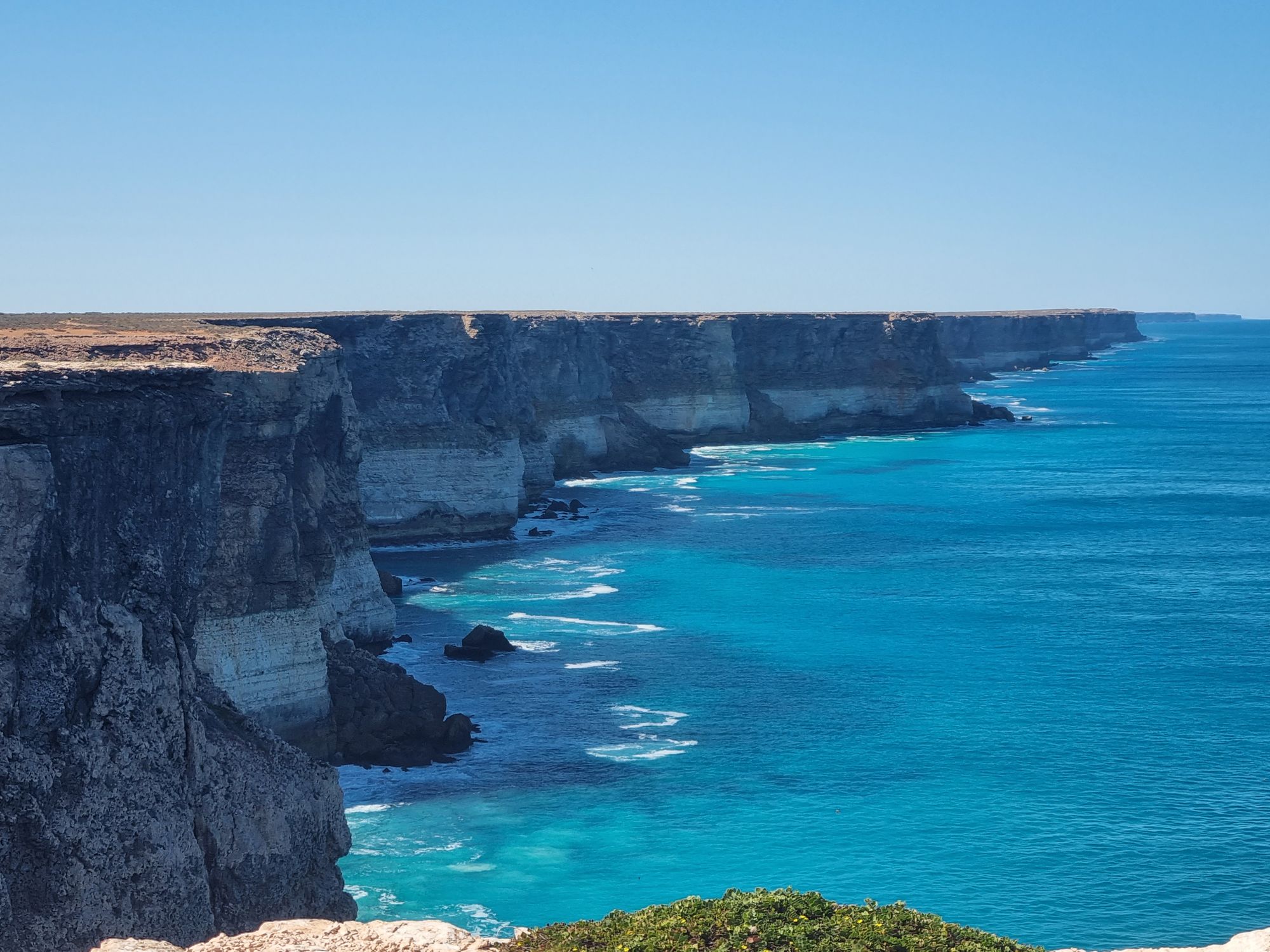
That's an interesting coastline. I can see the edge of the Roe Plain down there to the beach. I continue to follow the brown signs every twenty odd kilometres.

"You heading East? Wait till you see the next one"

For once I will make the point that the stupid phone camera isn't over saturating, the water is actually that blue.
I don't tend to do a lot of research for these "one road only" stretches, but boy this caught me by surprise.
After about two hours of these cliffs, the road veers inland a bit. This now feels like Nullabor ("no tree"), the landscape devolving to purely saltbush and dirt.

There's still life out here though. Every other kilometre there is a Shingleback sunning himself in the road. They seem to know to get out of the way for trucks.

There's a few birds of prey about, but not in anything like the numbers I saw in Western Queensland or the NT.
There's not a great deal to see from here. A few short hours later the saltbush starts to give way to arid stations, which gives way to farmland as I enter Penong.
An hour later, I enter the quarantine station to be asked if I'm transporting any livestock. Answering in the negative, I head for my motel for the evening. And go for a walk along the Ceduna jetty and port for sunset.
